Sunday, November 10, 2013 – continued:
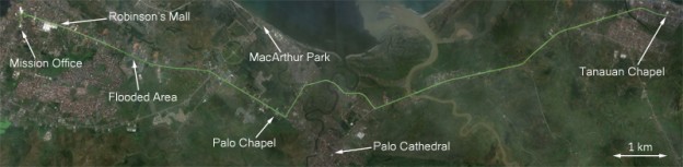
After securing two motorcycle rides from the bishopric in Tanauan, Elder Oakes and I were able to head north with considerably less risk than if we had been forced to try to walk the whole way. We were able to start off quite quickly since almost all of the traffic had been left at the bridge. Riding the motorcycle through the scene of destruction was an experience different from that of the ride we had taken earlier. Without a pane of glass separating us from the evidence of the disaster, it seemed more real than before. It was also at a much faster pace than when we had walked during the past two days.
The storm had transformed that landscape beyond recognition. As we drove through the rest of the city of Tanauan, it seemed more like something out of a movie than something that I was actually seeing. What had once been a nice, decent sized town was now a network of rubble, though far from a ghost-town. The survivors had built countless small shelters in the rubble as their initial efforts to undo what the typhoon had done.
Two days since typhoon had hit, the situation was continuing to deteriorate. We had heard that a small relief convoy had traveled down the highway earlier in the day, but a truck full of supplies was a drop-in-the-bucket compared to the growing need for food and water. Traveling through Tanauan, we saw where people had written in large letters on the road “S.O.S.” or “HELP! FOOD WATER.” For many of these people, there was nothing they could do except hope for help to come from elsewhere. One thing that all of these signs that were written on the highway had in common was that they were all written facing the shoreline, showing their hope and expectation that help was going to come by air from overseas.

Arial photo of the highway through Tanauan taken four days after the typhoon. (Source: AP/Wally Santana)
Continuing on our northward journey, our departure from Tanauan was relatively uneventful. The awful scene continued to expand with no end to the destruction in sight, but as it continued it became more and more numbing. While seeing the ruins of what once had been someone’s home had become the norm, the storm did not entirely cease to surprise us with something new and disturbing. As we passed through a major intersection, I saw a body on the left side of the road. Laid out on a tarp, it had been covered by a sheet that was too small to cover the limbs. The darkened skin and evident bloating were signs that this particular individual had drowned at some point in the storm. I was lucky because I wasn’t looking for them, and this was the only one I ever saw. Elder Oakes wasn’t so lucky, and after the ride he said that he had seen at least six of them, and not all of them were covered.
After leaving Tanauan, we entered into the municipality of Palo, the suburb of Tacloban known for the MacArthur Monument and a large cathedral. Judging by the damage taken by the roofing of the buildings there, we could tell that the winds hadn’t been quite as severe this far to the north, but the same low-lying shoreline that had made the area a prime landing ground for MacArthur’s army in WWII had also left the area more exposed to the powerful northern storm surge pushed in by the counter-clockwise winds of the typhoon. Because Palo was much more densely populated than Tolosa or Tanauan, this special exposure to the storm surge resulted in many more casualties than in any area we had already passed through.
Still keeping up a considerable pace, we were joined over time by a large number of other motorcycles that were headed in the same direction. By the time that we were nearing the center of Palo, we could tell that there was heavy congestion ahead; even under normal circumstances, the center of Palo was often quite crowded. Trying to save time, we ended up opting for the path less-traveled, a highway diversion around the center of the city. Again, I found myself hoping that all of the people turning left into the traffic instead of right weren’t doing so because they knew something that we didn’t. The diversion ended up being a good choice, though at one point the road was almost completely blocked by a fallen tree and power lines. Passing through, we had to lift up the power lines while we drove beneath them.
We probably saved an hour or so by going around the center of Palo, but as our diversion re-joined with the main highway, we found ourselves in traffic that made Manila’s notorious EDSA highway look like the Autobahn. Hundreds of tightly packed motorcycles and a single, bumper-to-bumper lane of cars and trucks covered the highway from shoulder to shoulder. Most of them were headed north, but a thin stream confined to the left shoulder was heading in the opposite direction. As we piled in with the rest of the motorcycles, we weren’t headed anywhere fast. The entire company was in a nearly complete gridlock, occasionally moving forward a couple feet to fill in the gaps that formed every minute or so.
At first we didn’t know why the traffic was almost completely stopped. We could see that a Department of Public Works and Highways (DPWH) excavator was on the road ahead, but it was idle and didn’t seem to be on the highway for any particular reason. Our drivers asked a person heading south on foot what was the problem ahead. He told us that there were fallen posts on the highway. What had happened was that the large concrete telephone poles that used to stand on the eastern side of the highway had all fallen onto the highway in the storm, and there was no equipment on hand capable of moving them while they were still linked by heavy steel power lines. The fallen concrete posts formed a bottleneck on the left shoulder every 200 feet for nearly a mile.
In the crowd of idling motorcycles and other vehicles, the air thick with engine exhaust. Many drivers, including our own, decided to turn their vehicles off to save gas, walking the motorcycle forward a few feet as spaces opened up. With very few clouds in the sky and only a very light breeze, the hot sun did nothing to help the situation on the ground. Now that we weren’t moving however, the old umbrella (which I had conveniently placed in my left pocket) proved very useful in providing myself and my driver with a little bit of shade.
As we continued slowly down the highway, we came by the Palo chapel. The building, located in an open and exposed field, had lost its entire roof, but had otherwise remained intact during the storm.
By late afternoon, after waiting for what must have been several hours stuck in traffic, we were finally able to get moving again. As we continued towards Tacloban, we passed a gas station. With no more electricity, the pumps had stopped working. A crowd of people with plastic bottles tied to long poles had gathered and were waiting to draw a liter of gasoline for their vehicles. If they hadn’t filled up recently before the storm, (it is the habit of most Filipino drivers in Region VIII to drive with as little gas in the tank as possible, never buying more than one liter of gasoline at once) they were probably now out of gas after idling on the highway for several hours. The availability of gasoline was of great concern for our drivers; my driver in particular had been counting on gas being available in Palo or Tacloban.
As we left Palo, we saw a government vehicle with a DPWH worker standing on top with bar cutters. As they drove along, workers standing beside the vehicle would signal the driver to stop as they approached low power lines crossing the street, and the man on top would cut them. We finally entered Tacloban City, passing beneath the sign that formerly displayed “WELCOME TO TACLOBAN,” but now only read “OME O TACLO.” Relieved that we were finally in Taclo, we had less than two miles to go before we would arrive at the mission office. The feeling of relief quickly left us, however, seeing that the road ahead was still under water.
Driving through the flood waters that still hadn’t drained from the city, we hoped that it wouldn’t get too deep for the motorcycle and its low air intake. Our scooters weren’t exactly designed to be amphibious vehicles. As we tailed a large army transport, I remember just hoping that we wouldn’t have to stop. Since we were riding a motorcycle, if we stopped, we would have to stabilize with our feet, and my shoes had only recently dried out from day before. Luckily, we ended up being able to make it through the half mile of flooded highway without stopping, beginning the “home stretch” past the landmark Robinsons’ Mall to the Mission Office.
Before the storm, the Robinsons’ Mall in Tacloban City had been the biggest and nicest building in Region VIII. As we drove past, we saw that it had been damaged catastrophically by the typhoon. The large glass windows on the front of the mall had all been destroyed. The massive sign-post that once stood in front of the mall had fallen and now lay in the small front parking lot. Judging by the size of the massive metal columns that had supported the sign, we were very lucky that it had fallen parallel to the highway and not across it.
Everything that wasn’t already destroyed by the typhoon had been looted. While supplies like food and water were the first things to go, eventually everything was taken. Even though there was no electricity, some missionaries saw people using a flat screen TV as a roof for their makeshift shelter.
As we passed through the area, we saw that while the mall had most likely been emptied on Saturday, the looting of other venues was still continuing, and large numbers of people could be seen struggling to move around large amounts of merchandise that they probably hadn’t paid for. One of the more popular commodities at the time we were passing through was beer taken from a nearby bottling plant. It seemed that everyone had decided to grab a crate, and for some reason, everyone had also decided that the most efficient way to transport it back to wherever they came from was by tying a string to the crate and dragging it behind them on the ground. It was an odd sight, and I could only hope that no one there was going to attempt to stay hydrated on beer and become hopelessly intoxicated in such a serious situation.
Nearing the intersection that would lead us to the Mission office, my driver spotted someone in the crowd that he knew. We stopped to talk with him, and tried to signal to Elder Oakes and his driver to stop, but they weren’t watching and continued straight to the mission office. The person that we met with turned out to be Tacloban Stake President Ricardo Aban, who had just made first contact with the Area Presidency in Manila. By chance he had come across a spot with a cellphone signal northwest of Tacloban in an area called San Juanico. He had taken advantage of the opportunity and made contact with the Area Presidency, which had been struggling to make contact with the church organization in Region VIII since the storm had hit. We updated President Aban on the state of the members to the south, as he was particularly concerned about the Tanauan Ward, which is part of the Tacloban Stake. He specifically asked about the number of confirmed deaths from Tanauan, and fortunately, we didn’t have many names to report. We also took the opportunity to inform President Aban about the missionaries that had gone missing in Tanauan after they had left their companions without telling anyone.
After we had finished telling President Aban about Tanauan, he told us more about his talk with the Area Presidency. I was the first missionary in the Philippines Tacloban Mission to get the message, since President Aban was still on his way to find Mission President Andaya when he ran into us. He told us that the Area Presidency was planning to evacuate the entire Philippines Tacloban Mission by Tuesday. He said that they had told him that whether it was by boat, a privately chartered airplane, or helicopters, they were determined to get all 204 of us off of the island as soon as possible. He also told us that they would be expecting the first of the Church’s relief supplies to be arriving from the North beginning that night.
Elder Oakes and I had already contemplated what was going to happen to the mission because of the storm. We first concluded that missionary work could not continue in the area under the current conditions of instability and lack of safety. Furthermore, we had no communication since all utilities had been destroyed in the storm. We couldn’t have concluded, however, that they were going to be evacuating the entire mission, not just those in the most-affected areas. Previously, we hadn’t been able to rule out if we were going to become engaged in the humanitarian effort rather than being sent elsewhere.
The immediacy and resolution embodied in the message from the Area Presidency was very reassuring to us in a situation where reassurance was indeed quite difficult to come by. Prior to this message, we had no assurance of any help coming from outside. Not only were we assured that help was in fact on its way, but we were going to be able to leave this scene of desolation and all of its uncertainty within two days.
As we said goodbye to President Aban and continued on to the Mission Office, I was reminded that I was still in Tacloban, and although it was good news that we would be leaving, Tuesday was still two days away. When we reached the intersection leading to the church, we found part of it deep underwater, and were forced to go around the intersection the long way and underneath some downed power lines to make it to the mission office.
When we finally made it to the mission office, it was very late in the afternoon. The first thing that we saw was that the parking lot was covered more than three inches deep in dark grey mud left by the storm surge. The mission vehicles had all been pushed to one end of the parking lot and lay where the storm surge had left them. We had hoped that the mission office, mission home, and stake center might have been spared by the storm surge, imagining that the complex was further inland than it actually was. The mission office was locked up and closed, so we went to meet with the members at the chapel to ask where the missionaries were.
The chapel was intact, but the floor was covered in mud despite all efforts to keep it mopped and clean. I was directed to the mission home, located behind the chapel, where I was told the missionaries were. Walking around to the back, I was greeted by Elder Oakes and a small group of other missionaries. I was relieved to finally see some other missionaries here, but I found it odd that everyone except Elder Oakes and I was wearing casual clothes.